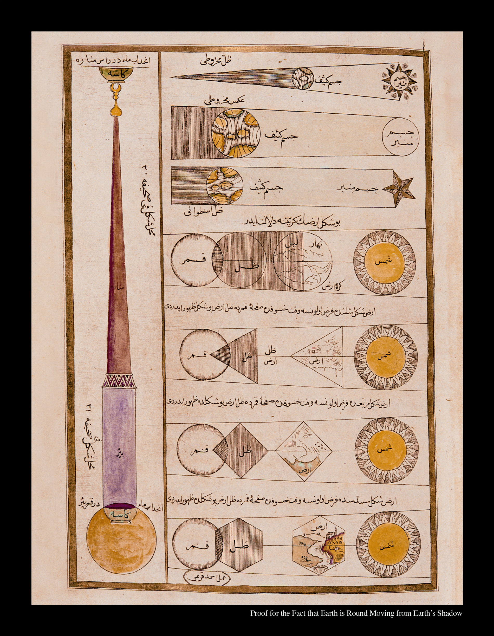
On this page there are two expositions dealing with different subjects. The first, on the left side of the page, concerns a model used to express a problem regarding the effects of air pressure. There it is claimed that if a completely full bowl of water is placed at the bottom of a very deep well and drawn up to the top of a very high minaret located right next to the well, the water in the bowl will overflow. The other concerns a light source and the shadow cast by an opaque body, and comprises drawings which explicate the dimensions and shapes of the body and its shadow. Here it is posited that the light source must be larger than the opaque body, and by demostrating how solar and lunar eclipses would occur in order to produce triangular, rectagular, or hexogonal shadows, the effort is to verify that the heavenly bodies are round by demonstrating that the shadows in solar and lunar eclipses are necessarily circular.
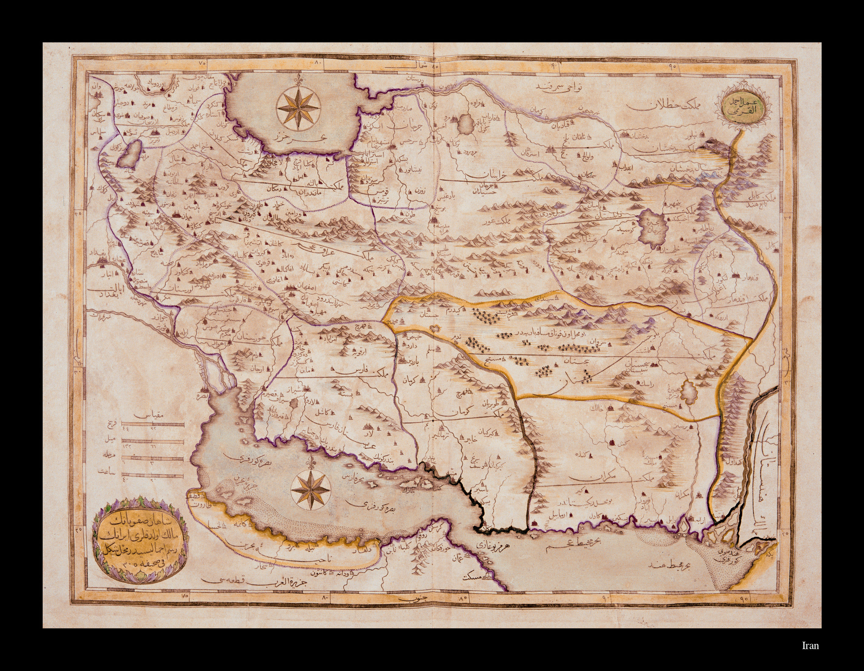
A map of Iran by Kırımî Ahmed comprising the lands ruled by the Safavi Shahs. This map does not have lines of latitude and longitude, and directions are established by means of two projection centers, one located in the Persian Gulf and the other in the Caspian Sea. Even without lines of latitude and longitude, the map is provided with a mathematically-based scale. Distances are measured in terms of the day’s journey, the fersah (approx. 3 miles), the mile, and the hour. Rivers, mountain ranges, great lakes and the borders of countries are drawn in between the 20-40 degree north parallels.
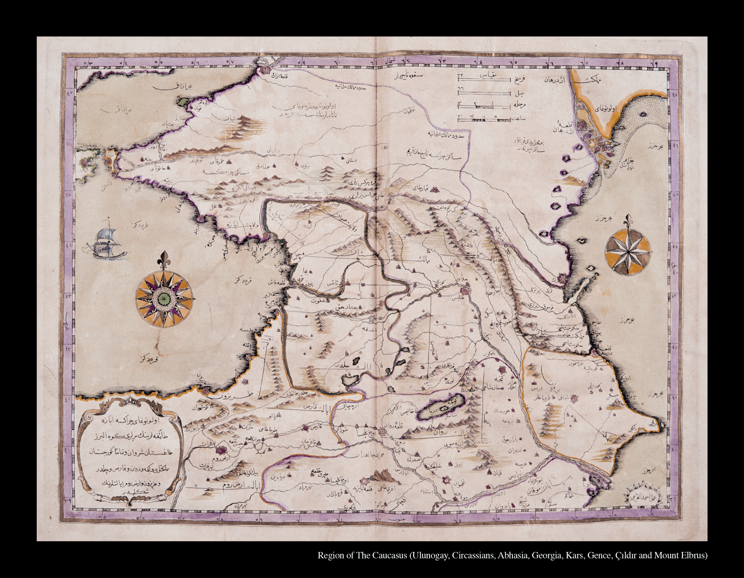
The Caspian Region: A map of the Caucasus showing the regions where the Ulunogay, Circassian and Abaza people reside; the lands of Dağıstan, Shirvan, and Gürjistan; and the provinces of Genje, Revan, Kars, Çıldır, Trabzon and Erzerum. Even without lines of latitude and longitude, the map is provided with a mathematically-based scale. Distances are measured in terms of the day’s journey, the fersah (approx. 3 miles), the mile, and the hour. Rivers, mountain ranges, great lakes and the borders of countries are shown in different colors in the area between the 39-48 degree north parallels and 55-69 degree east meridians. The Black Sea is drawn in such a way as to show the sovereignty of the Ottoman State.
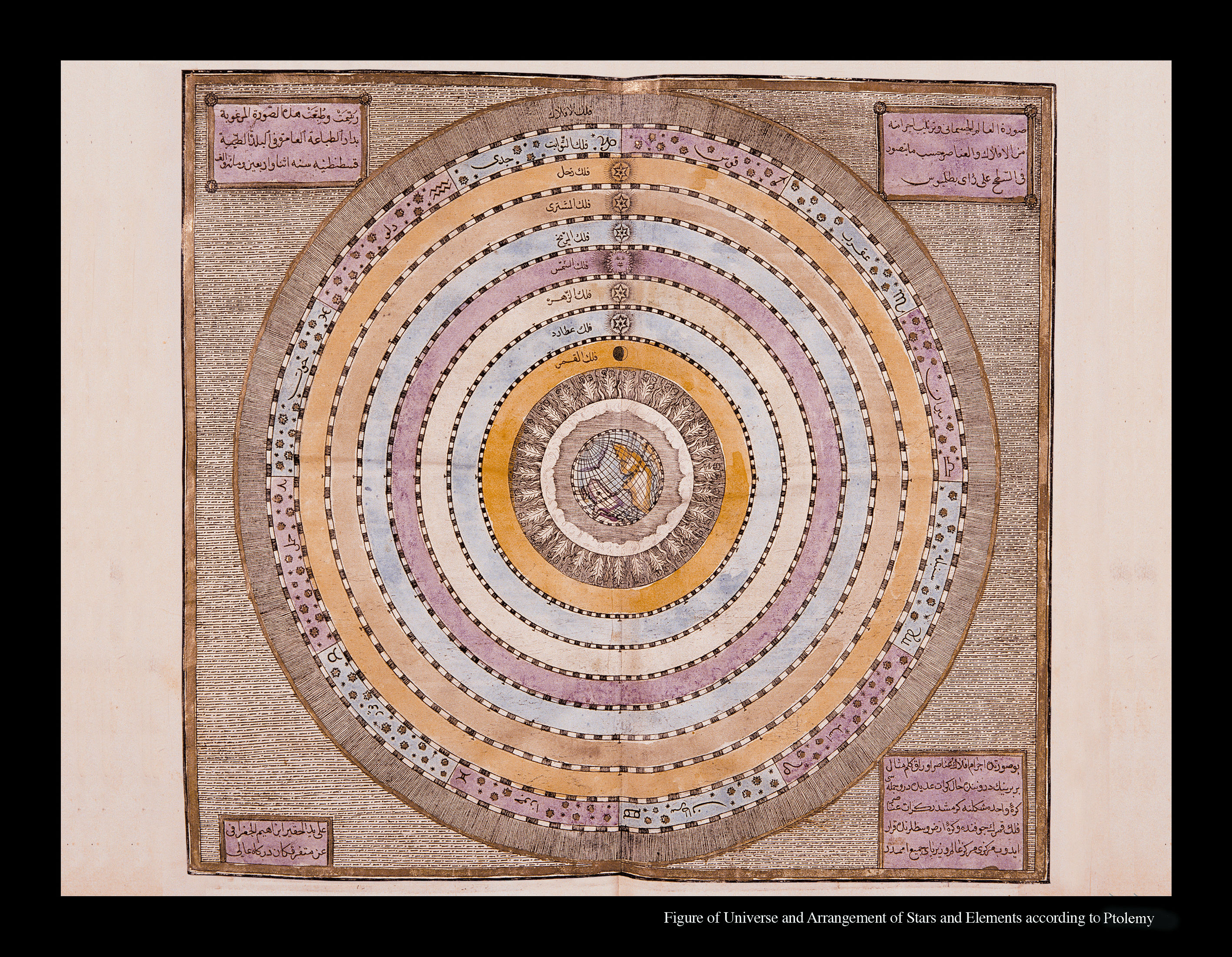
A diagram showing the order of the heavenly bodies according to the geocentric model of Ptolemy. According to the Ptolemaic model, the earth is imagined to be fixed at the center of the universe and surrounded by concentric spheres. The fixed stars of the Zodiac are found in the spheres of the moon, Mercury, Venus, the sun, Mars, Jupiter and Saturn. Beyond these is the sphere of spheres (the atlas sphere), thought to embrace the entire universe. It was drawn by Jeografî, a pseudonym of İbrahim Müteferrika himself, renowned for establishing the first Ottoman printing press, which published Displaying the World.
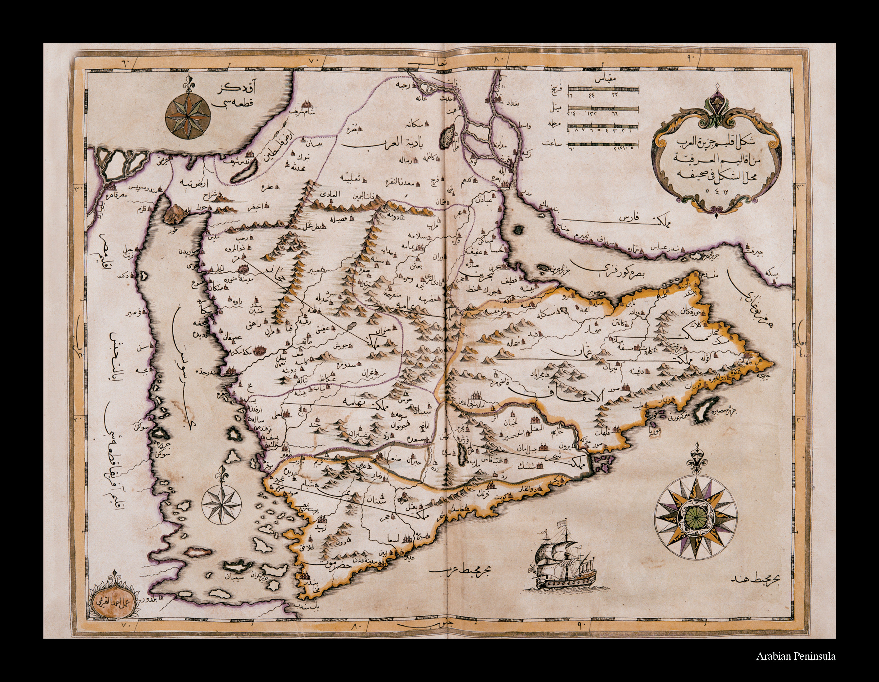
This map of the Arabian peninsula and Iraq illustrates page 543 of Katib Çelebi’s Displaying the World. Drawn by Ahmed al-Kırımî, it has no lines of latitude and longitude. This large-scale map covers the geography between the 15-35 degree north parallels and the 60-90 degree east meridians. It shows the states, provinces, tribes and cities of the Arabian peninsula and Iraq region. Rivers, lakes, mountain ranges and coasts are indicated with crosshatching or colored lines. It is circumscribed in the west by the lands of Egypt, bounded by the Mediterranean in the north, and the Sea of Suez; by the Arabian Sea and the Indian Ocean in the south; and in the east by the Strait of Hormoz, the Persian Gulf and Persia. Aspects are shown by means of three projection centers: one in the Indian Ocean (16 aspects), one in the Mediterranean (8 aspects), and one in the Red Sea (8 aspects). Distances are measured in terms of the day’s journey, the fersah (approx. 3 miles), the mile, and the hour.The map is decorated with an Ottoman galleon voyaging on the Indian Ocean.
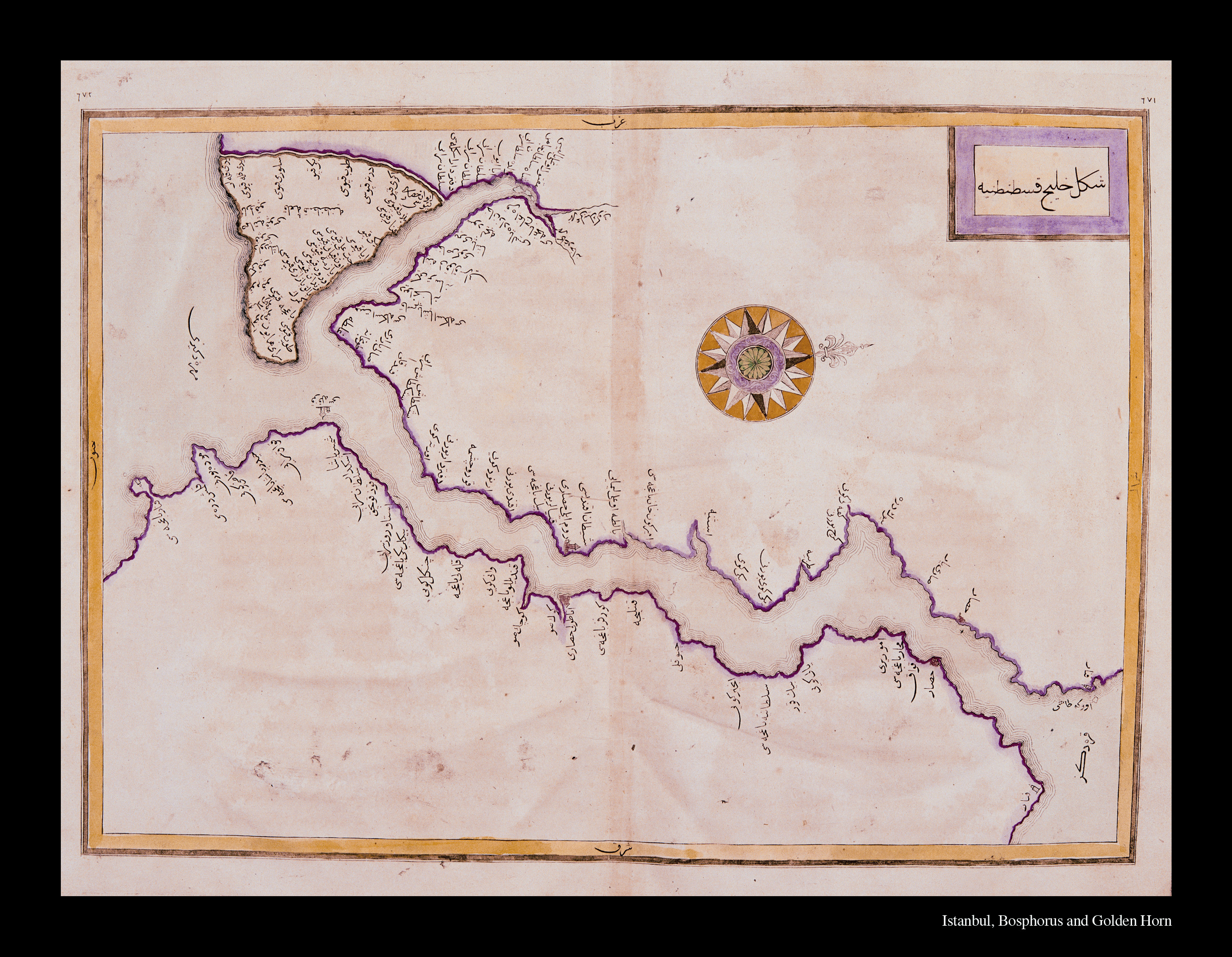
This map of Istanbul, the Bosphorus and the Golden Horn is the largest-scale map in Displaying the World. The cartographer is not identified. The map has one projection center showing true north, but no lines of latitude and longitude or scale and evaluation. It is clear from the lack of distortion in comparison with today’s maps, however, that it is mathematically-based. The neighborhoods and sites of the Empire’s capitol, of the Golden Horn and the Bosphorus, are named with the same names they have today. Places further from the coasts are not named. There are no special geography legends other than the fortresses shown for the city walls, the Castle of Rumelia, the Castle of Anatolia, Leander’s Tower and Anadolu Kavağı. Nor are rivers, lakes or summits shown.
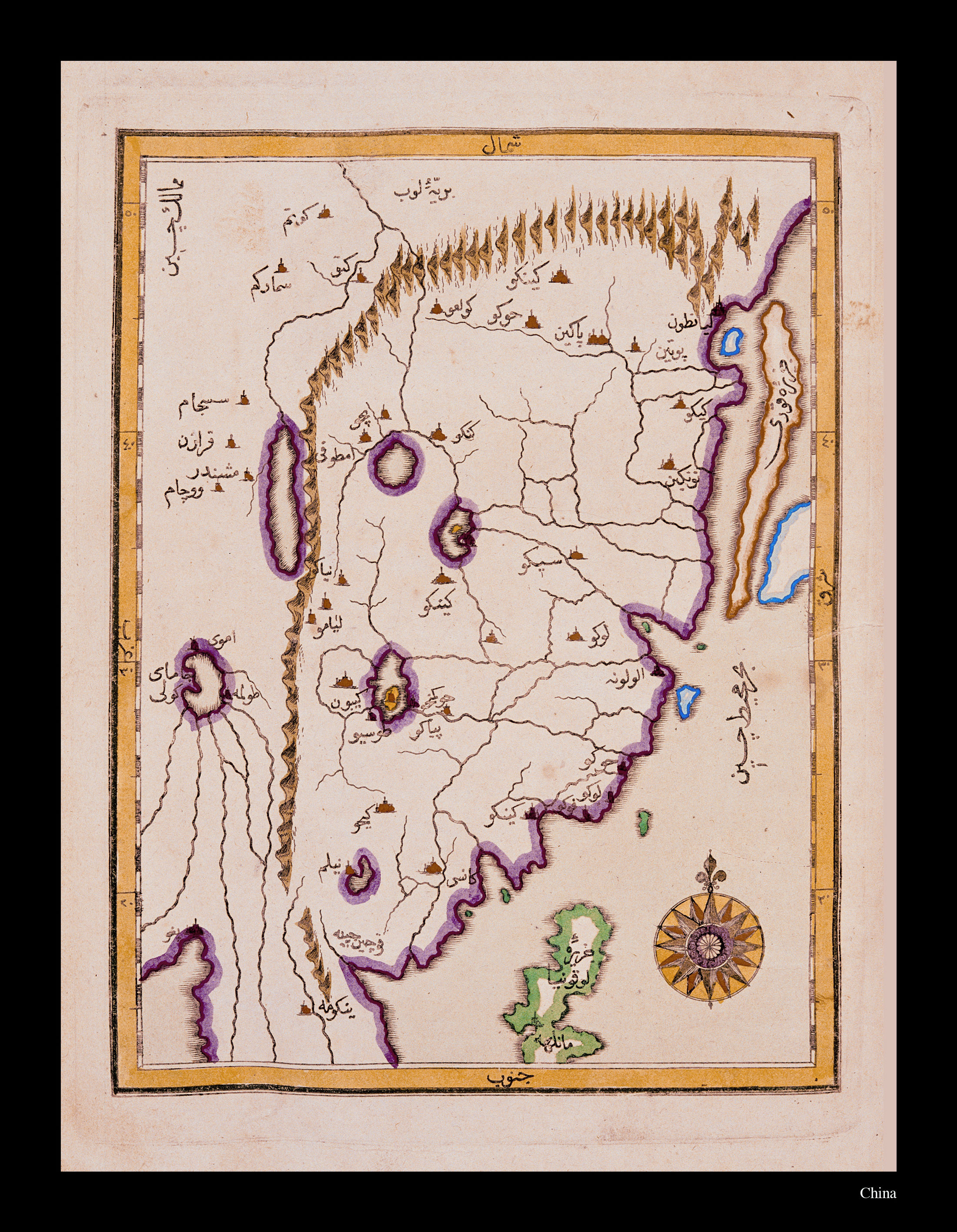
This map encompasses the geography between the 10-50 degree north parallels and 90-130 degree east meridians. It shows the regions from the Sea of China to the Korean peninsula in the north and in the south as far as Manila. The Thailand peninsula is barely visible on the map. The great Hinggan Mountain Range runs south from the region of Manchuria in the west. The single projection center in the South China Sea shows the true directions of the compass. Great lakes, rivers and mountains ranges are shown with crosshatching, while major cites are shown with fortress legends. The Korean peninsula is pictured as an island.
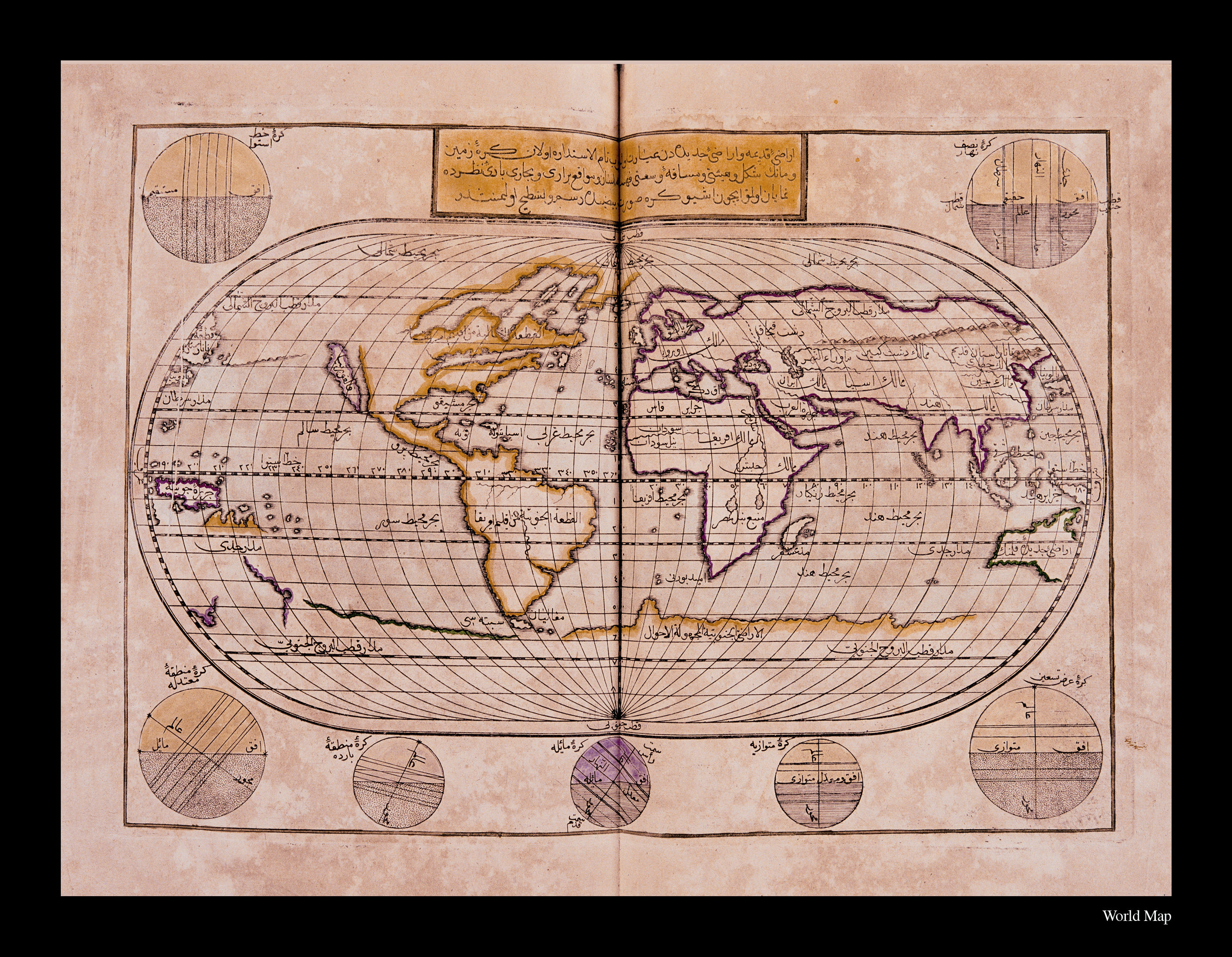
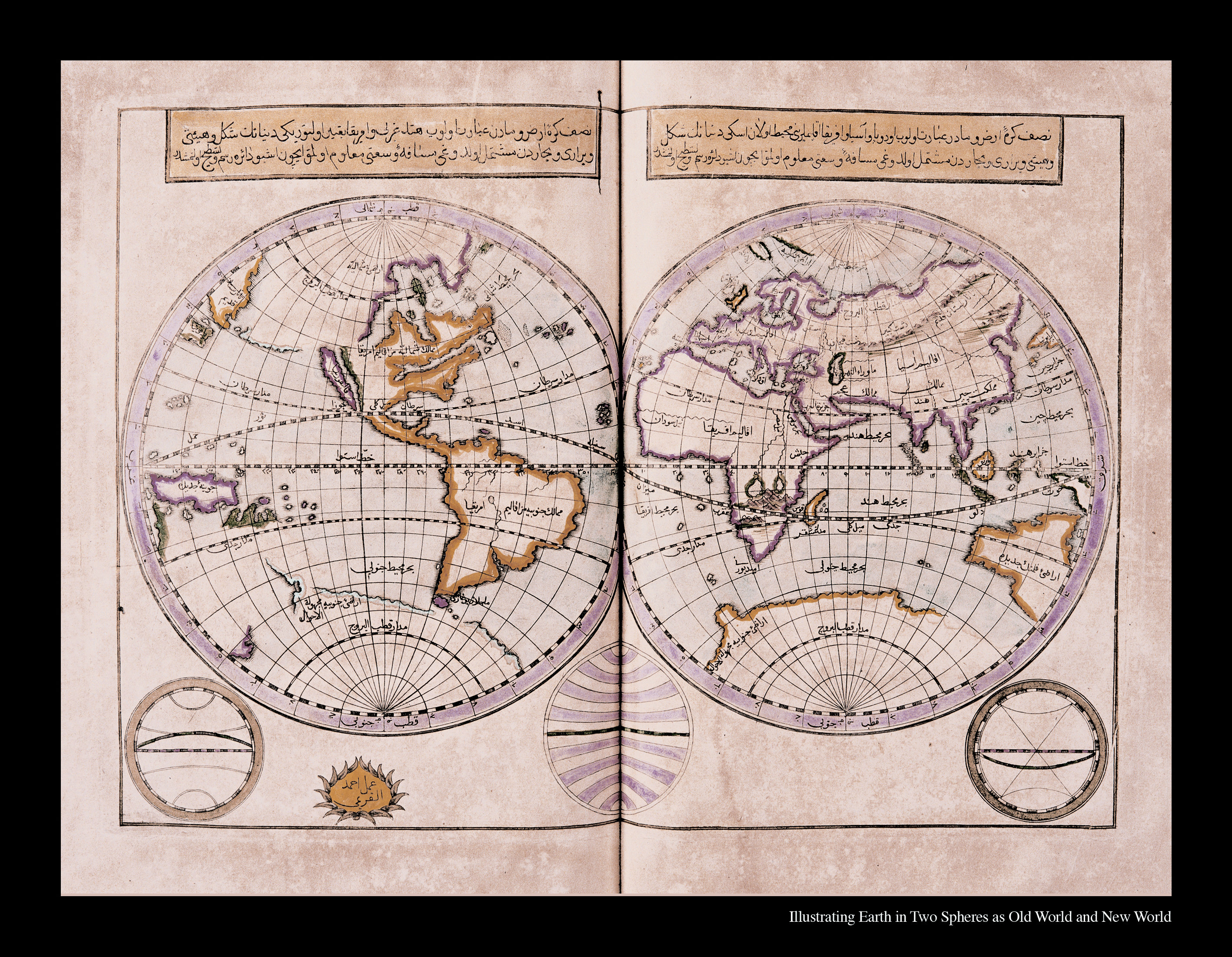
This oval globe in the form of a flattened egg has been drawn showing the lands and oceans of the Old World (the continents of Asia, Europe and Africa) and the New World (the continents of America and Australia) in circular form so that the shape and size of the sphere of the earth and the oceans may be perceived, and the locations of continents and oceans may be easily seen. It has a geographical partitioning consisting of a total of 36 meridians at ten-degree intervals, and 18 parallel circles at 10- degree intervals, 9 in the south and 9 in the north. The area of projection is exactly equal to the area of the globe, and equal to the Equatorial-length pole or twice the length of the prime meridian. The parallels, as in Gerardus Mercator’s map of the world, are correct partitions. The 180-degree meridian is in the form of a half-circle at farthest east and farthest west. The prime meridian separates the co-equal latitude parallel circles and the co-equal longitude meridians into equal partitions of parallel circles.
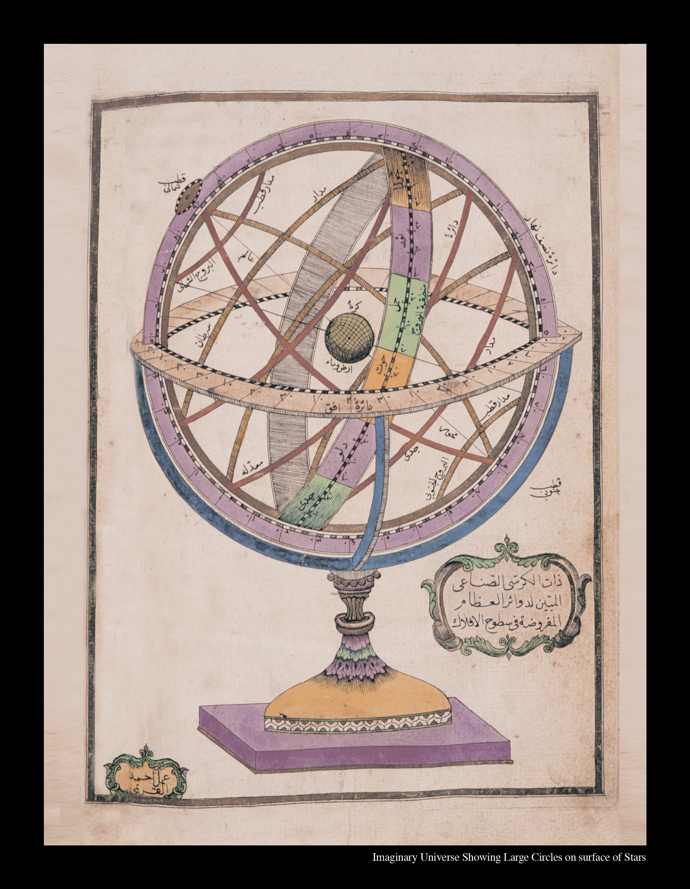
Zt'l-Krs (The horizon-oriented coordinate system known as 'The Ringed Instrument'): This instrument, whose origins go back to the Hellentistic period, was called by the Ottomans 'zat-l halak,' which means 'ringed instrument.' In the West it was called a 'meteoroscope', 'armilar sfer'(ringed sphere) or 'astrolabium armilare' (ringed astrolabe). The instrument is drawn with the supposition that it is located at the center of the earth. The instrument fixed with a handle drawn by Ahmed el-Kirim was called Zat'l-Krs (instrument with pedestal). This drawing of the sky was added by Mteferrika to Displaying the World and in modern times became well-known in the East and West. This is the coordinate system tied to the elliptical circle, generally consisting of 6 rings, and shows the constellations and tropics. The world is at the exact center.
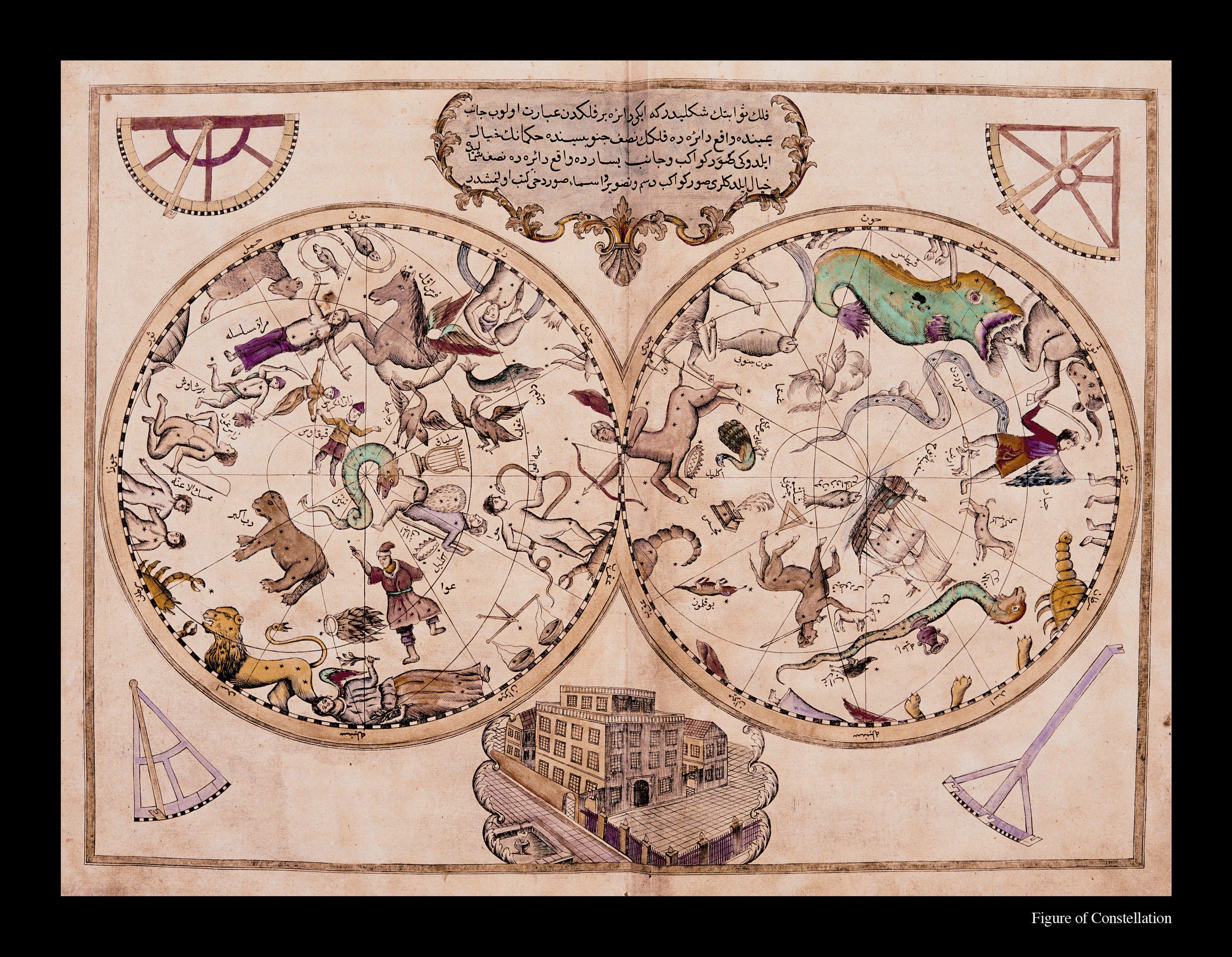
Celestial Sphere: An image showing the universe as scholars imagined it to consist of “spheres” arranged one inside the other with the level of the fixed stars outermost. The circle at the right side of the drawing relates to the fixed stars of the southern hemisphere, and the one on the left to those of the northern hemisphere. The positions and names of the 12 signs of the Zodiac are indicated at the circumference of each circle.
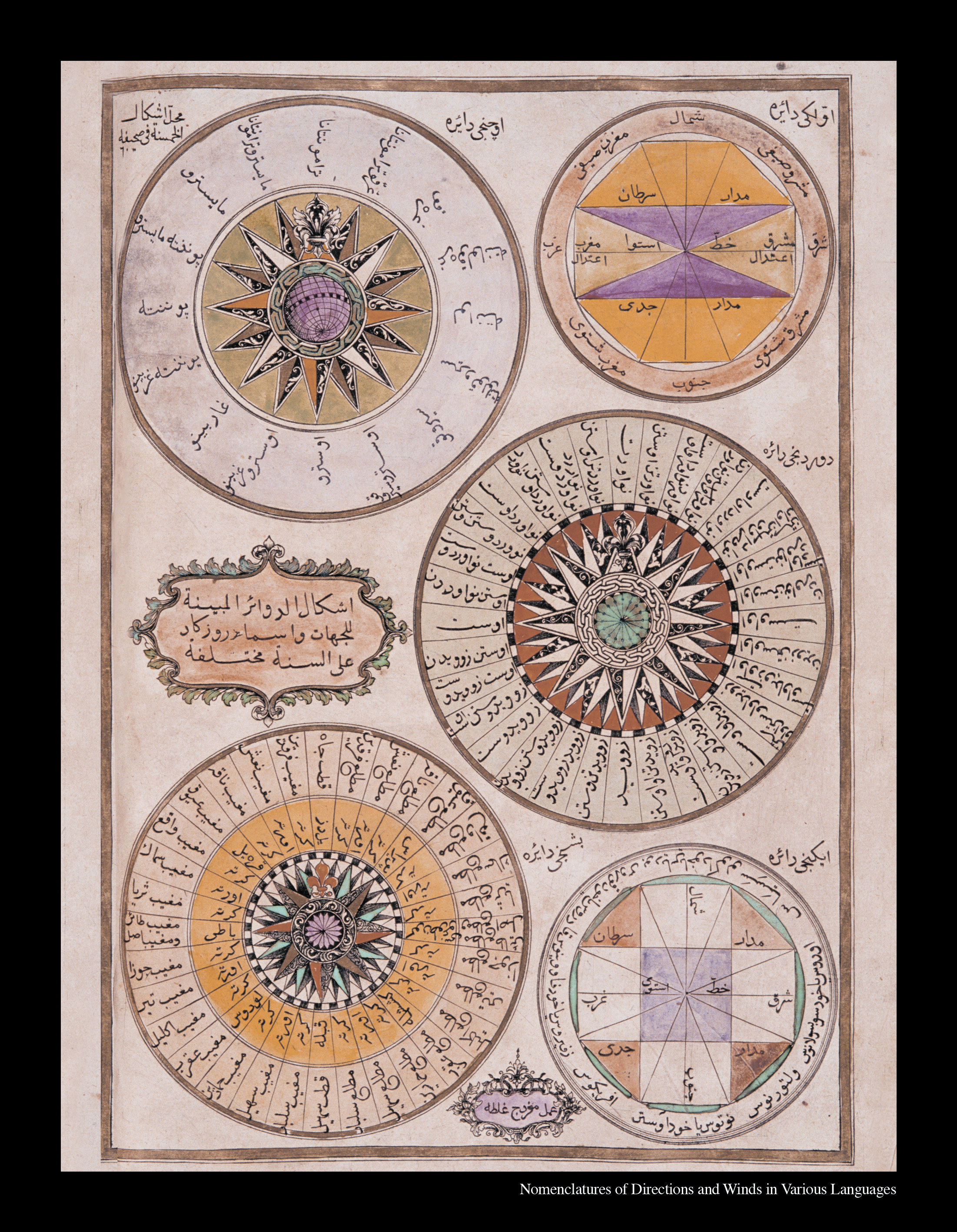
Circles showing the names of the directions and the winds in various languages: (drawn by Galatalı Mıgırdıç). Images of five different circles. In the first circle are the Tropics of Capricorn and Cancer, the equator, and the four cardinal and 4 ordinal directions: East, Northeast, Southeast, West, Northwest, Southwest, South, and North. The second circle shows the same points with their Greek names.
Küre-i arz ve mâ’(The globe): This comprises two spheres. The first contains Asia, Europe, Africa and their environs, making up the Old World. The second hemisphere contains “West India,” America, that is to say the newly discovered world. The image was drawn by Ahmed al-Kırımî. It has lines of latitude and longitude, clime zones, the poles, the equator, and the names of continents and some countries and regions are indicated. The as yet undiscovered northern regions of the continent of America, which is named “The New World,” are left blank. Florida is depicted as an island. The continent of Australia in the southern hemisphere is indicated as “The Continent of New Holland.”
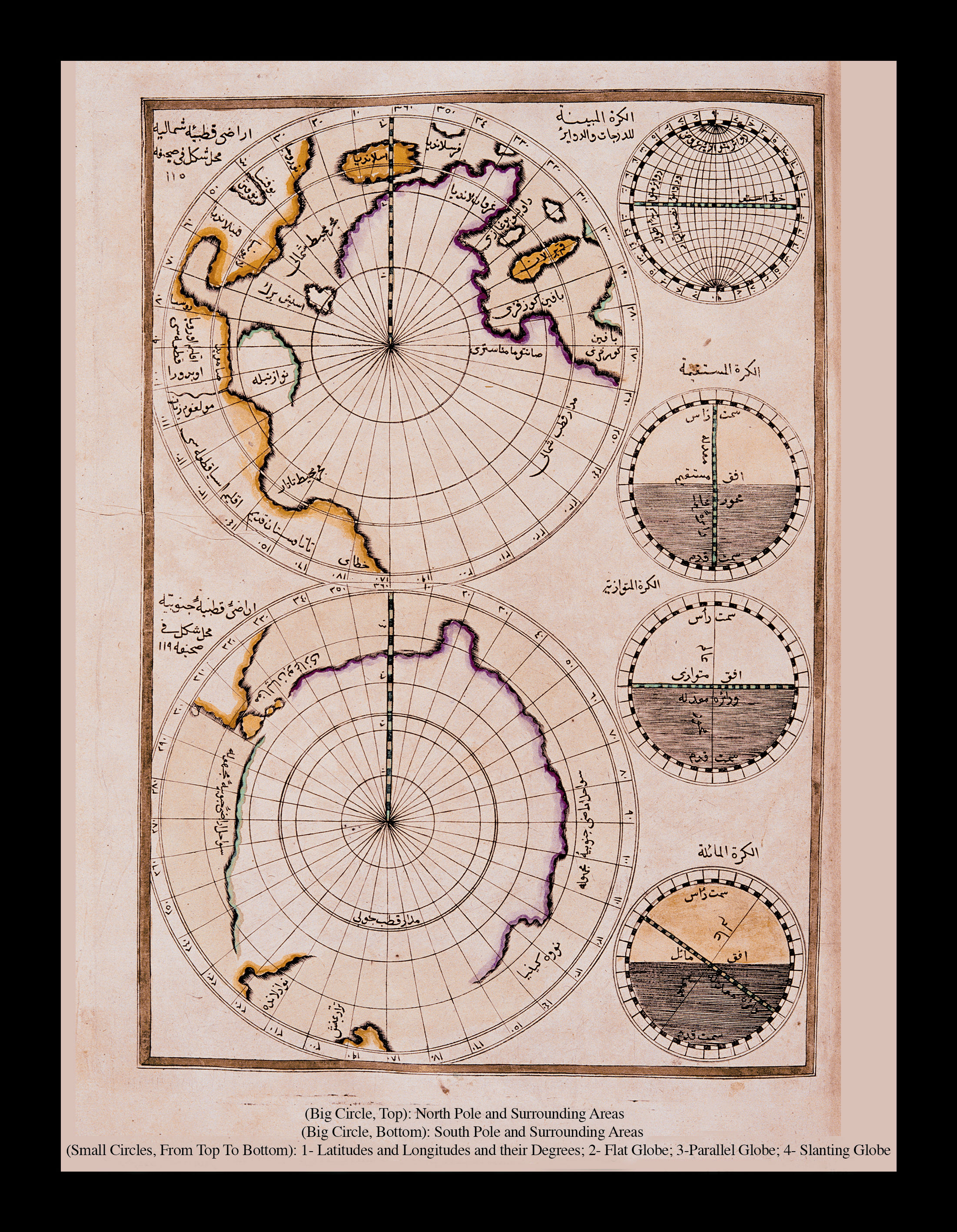
Two large circles show the areas between the 0-30 degree north and south parallels of the North and South polar regions. Of the other four circles, the first shows the lines of latitude and longitude; the second, the horizontal axis of the earth; and the third, the fourth elliptical declination of the parallel axis of the earth. The circle of the North Pole at the top includes the Arctic Ocean and Iceland, Norway, Greenland, Finland, Baffin Bay and northern countries and sites. The circle of the South Pole shows the Straits of Magellan, New Zealand, New Guinea and undiscovered lands.
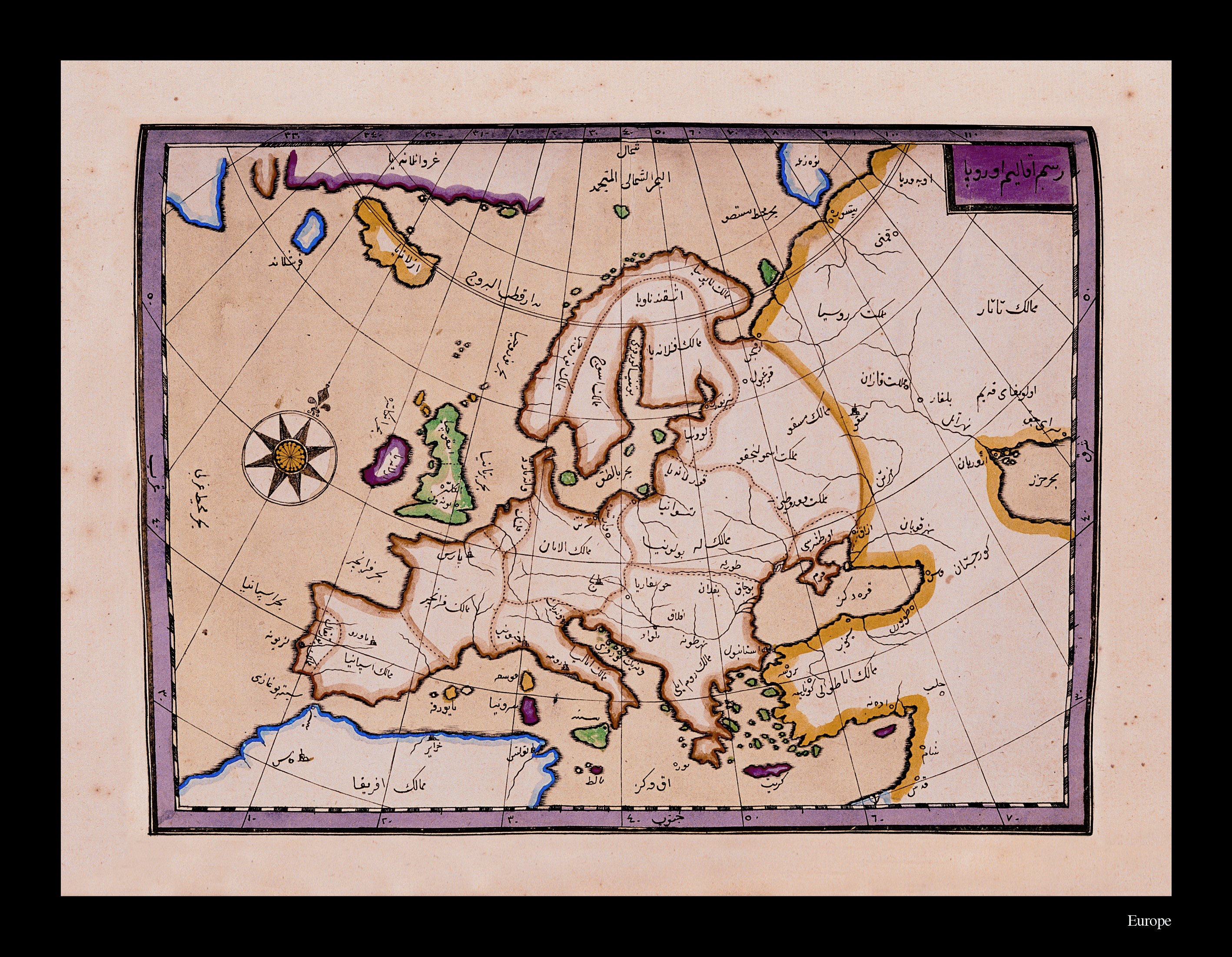
Resm-i klim-i Avrupa (The Continent of Europe): The map shows the countries and capitol cities of Europe and important rivers, but does not include mountain ranges, although the Map of Europe by Gerardi Mercator does. Different colors are used to distinguish the boundaries of Asia, Africa and the Arctic Ocean. The Mediterranean, the Black Sea, islands, the Caspian and coastlines are indicated. The Ottoman Empire is shown as divided into two regions, the Lands of Anatolia and the Lands of Rumelia. Also indicated are Poland, Germany, France, Spain, Sweden, and in Asia such countries as the Lands of the Tatars, Russia and Georgia. The map has no scale and the cartographer is unknown. It has lines of latitude and longitude and an octagonal projection center used in classical maps, although not in Mercator’s Map of Europe.
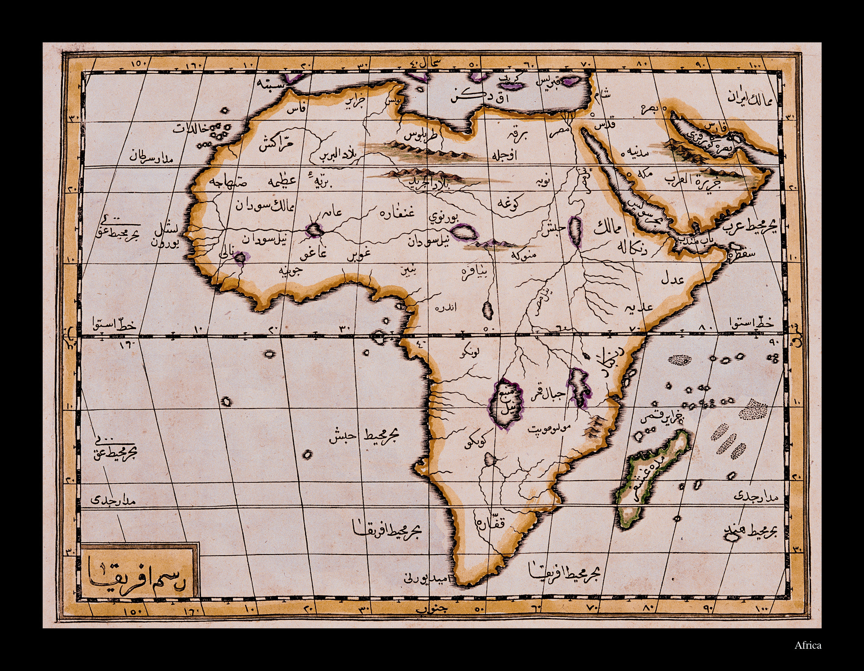
Resm-i Afrika: Africa. The map of Africa in Displaying the World is the second depiction of the continent. The map is done in the manner of Mercator with the lines of latitude and longitude intersecting at right angles. The equator is indicated with a thicker line, and the Tropics of Capricorn and Cancer with thinner lines. Large mountain ranges, rivers and lakes are not shown. The map indicates the names of places and important centers from the south Mediterranean to the African Sea and Cape of Good Hope. The Isle of Madagascar and the Arabian peninsula are depicted inside the African continent.
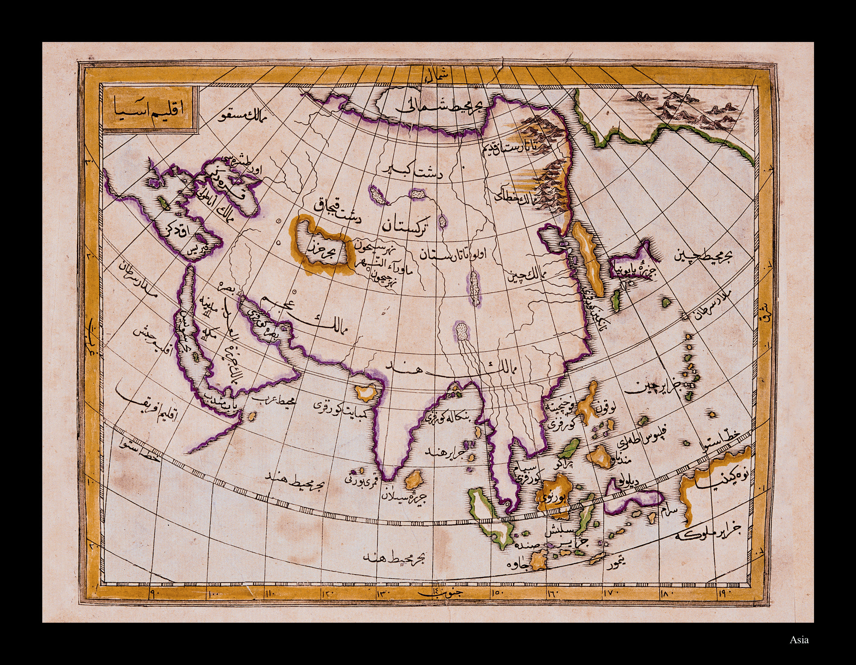
Iklim-i Asya (The Continent of Asia) Asia, the largest continent of the Old World, is depicted as beginning at Europe and northern Africa and including the islands of the Pacific Ocean. Rivers, great lakes and important mountain ranges are indicated. Persia, India, China, the Great Salt Desert of Khorasan, the Sarmatian Steppe, Turkestan, the Sea of China, Japan and in the Northwest, the Lands of Moscow and major cities are named. The northwestern shores of the American continent (Alaska) are shown in the northeastern corner. Although the geography covered is the same as that of Mercator’s Map of Asia, the drawing technique is comparatively simple.
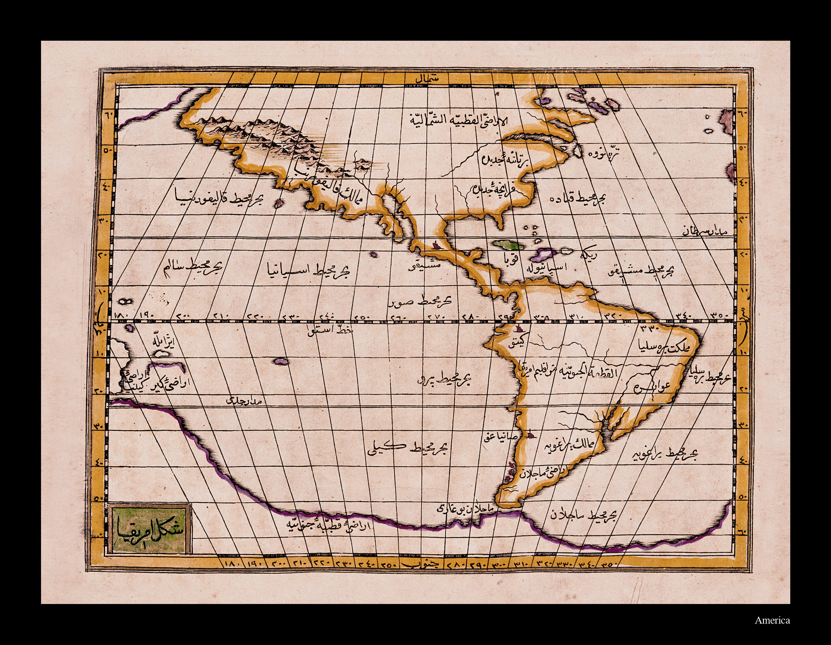
Sekl-i Amerika (America). The map of America, also called The New World, covers the region between the 60 degree parallels in the north and south. The lines of latitude and longitude are drawn intersecting at right angles in the manner of Mercator. The continent is joined to the north Pole in the north and in the south is separate from the Straits of Magellan and the continent of Antarctica. The major regions of the North American continent are New Britannia, New France, Terra Nova and the Lands of California, while Mexico, Cuba, Espanola, Brazilia, Paraguay, and the Magellan territories are the major regions of North, South and Mesoamerica. The islands of the Atlantic and Pacific oceans are also included on the map. Rivers, and the mountain ranges of California, are indicated. Although the geography covered is the same as that of Mercator's map showing America within a circle, the drawing technique is comparatively simple.
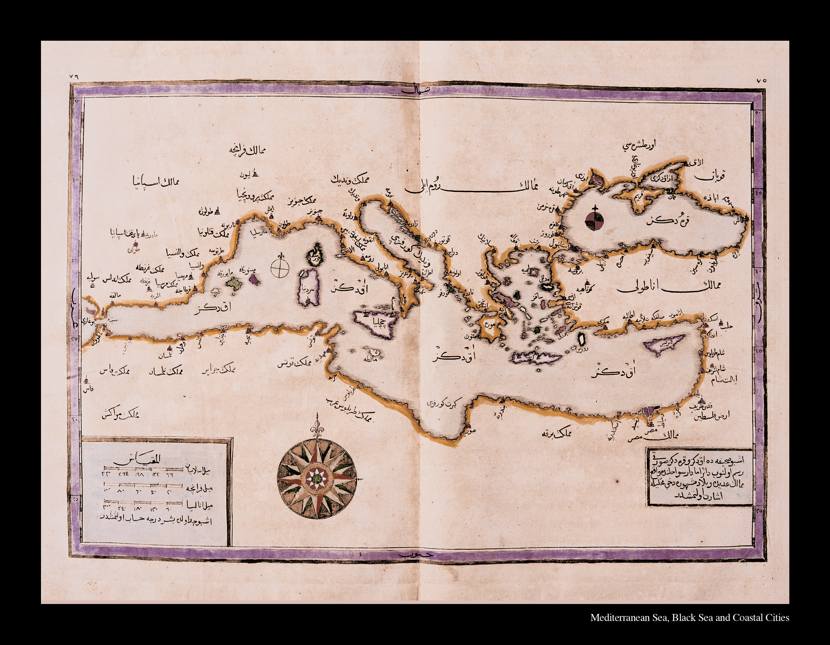
Map of the Mediterranean and the Black Sea: The map shows Mediterranean and Black Sea territories, most of which were part of the Ottoman Empire: the Lands of Anatolia and Rumelia; Egypt, Cyrenaica, Tripoli, Libya, Tlemcen, Fez, and Morocco in North Africa; and in Europe countries of the Mediterranean littoral such as Andalusia, Valencia, Genoa, Veniz, France, Spain, Italy and Sicily. The map has no lines of latitude and longitude and directions are established by means of a projection center in the region of the Great Sahara. Even without lines of latitude and longitude, the map is provided with a mathematically-based scale. Three types of measures of distance are used: “the Islamic mile,” “the French mile,” and “the Italian mile.” Each mile is calculated by five degrees.
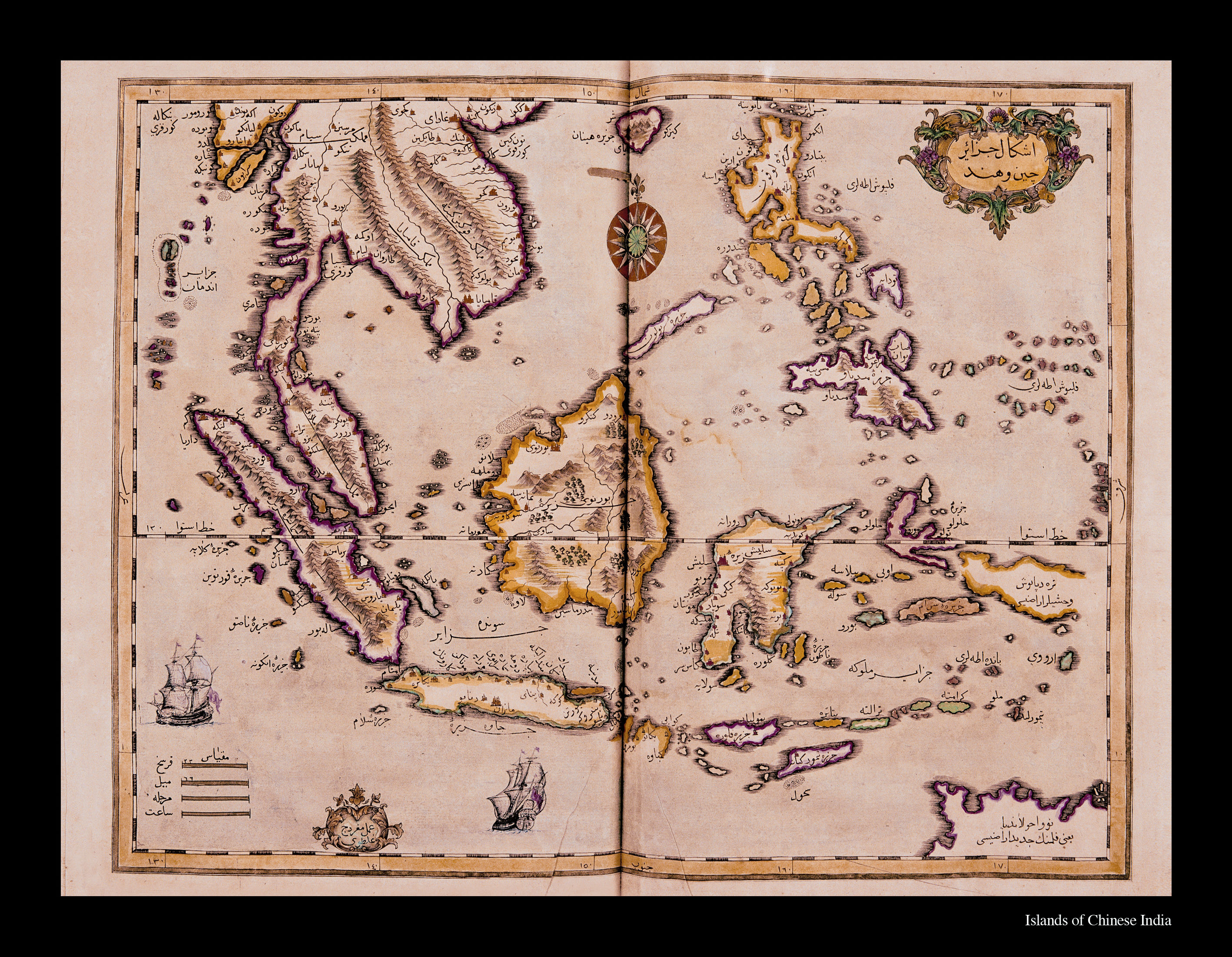
Eşkal-i Cezire-i Çin ve Hind (The Islands of China and India) The map was drawn by Galatalı Mıgırdıç and has no lines of latitude and longitude. Directions are established by means of a projection center in the Sea of China. Even without lines of latitude and longitude, the map is provided with a mathematically-based scale. Distances are measured in terms of the day’s journey, the fersah (approx. 3 miles), the mile, and the hour. The geography shown on the map in the areas between the parallels approximately 20 degrees north and south of the equator covers Borneo, Siam, Sumatra, Java, Baltimore, Guinea, the Philippines, Cambodia, Indonesia, China, India and the eastern part of the Indian Ocean. The map is decorated with two magnificent Ottoman galleons voyaging on the Indian Ocean.
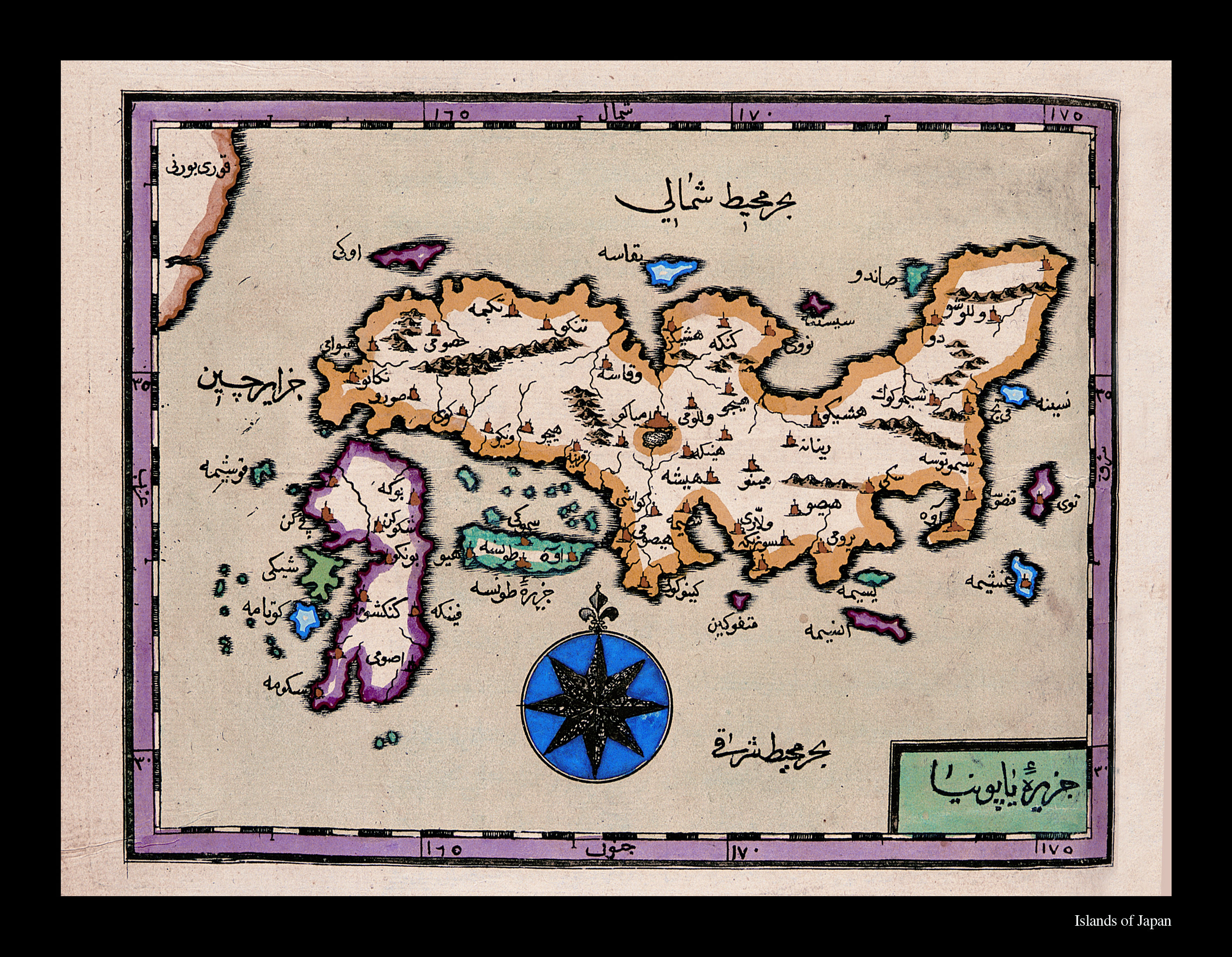
Cezire-i Yaponya (The Island of Japan). The point furthest east in Displaying the World is Japan. Rivers, mountain ranges and great lakes are indicated. There are no lines of latitude and longitude. The map covers the geography between 30-35 degrees south and north, and the 160-175 degrees east meridians. It has no scale measure. An attempt to show directions is made by means of a simple weathervane indicating north. An attempt is made to show all of the cities of Japan.